

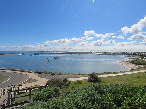

denison surf beach
Surf spot · Australia
Is it worth the trip?
20Poor out of 100 for your dates
Best on Mon 9: 4 ft swell at 12 s, onshore wind, 18 kn (33 km/h), sheltered (estimated): holds up in a blow
Tue 3 · 0 out of 100
- Swell
- 6 ft9 ssoft
- Energy
- 599kJ
- Wind
- S 6 kn
- Temp
- 20°C
Wed 4 · 26 out of 100
- Swell
- 5 ft10 scrumbling
- Energy
- 463kJ
- Wind
- ESE 5 kn
- Temp
- 20°C
Thu 5 · 0 out of 100
- Swell
- 7 ft11 scrumbling
- Energy
- 1,107kJ
- Wind
- S 10 kn
- Temp
- 20°C
Fri 6 · 12 out of 100
- Swell
- 6 ft11 scrumbling
- Energy
- 721kJ
- Wind
- S 12 kn
- Temp
- 20°C
Sat 7 · 12 out of 100
- Swell
- 4 ft6 smushy
- Energy
- 118kJ
- Wind
- SSW 12 kn
- Temp
- 20°C
Sun 8 · 28 out of 100
- Swell
- 4 ft7 smushy
- Energy
- 148kJ
- Wind
- SSW 14 kn
- Temp
- 20°C
Mon 9 · 32 out of 100
- Swell
- 4 ft12 scrumbling
- Energy
- 478kJ
- Wind
- S 18 kn
- Temp
- 20°C
Tap a day for waves, wind and the temperature. Full forecast
Forecast: next 10 days
Full forecast- Mon 20, too big
- Tue 30, too big
- Wed 426, poor
- Thu 50, too big
- Fri 612, poor
- Sat 712, poor
- Sun 828, poor
- Mon 932, poor
- Tue 1032, poor
- Wed 1152, fair
The spot in six facts
- Faces Wtakes swell from the W
- Offshore: Ewind from the land
- Intermediate +who it suits
- Works 3–14 ftof swell
- Water 21 °C2 mm shorty
- Best May–Jun3 good days in 7
Full forecast
every day, every number
| Day | Score for intermediates | Swell | Energy | Wind | Temp |
|---|---|---|---|---|---|
| Mon 2Nov | 0, too big | 6 ft10 ssoft7 ft at break (est.) | 687kJ | wind from the north-east, 5 knots | 20°C |
| Tue 3Nov | 0, too big | 6 ft9 ssoft7 ft at break (est.) | 599kJ | wind from the south, 6 knots | 20°C |
| Wed 4Nov | 26, poor | 5 ft10 scrumbling6 ft at break (est.) | 463kJ | offshorewind from the east-south-east, 5 knots, offshore | 20°C |
| Thu 5Nov | 0, too big | 7 ft11 scrumbling7 ft at break (est.) | 1,107kJ | wind from the south, 10 knots | 20°C |
| Fri 6Nov | 12, poor | 6 ft11 scrumbling6 ft at break (est.) | 721kJ | wind from the south, 12 knots | 20°C |
| Sat 7Nov | 12, poor | 4 ft6 smushy3 ft at break (est.) | 118kJ | wind from the south-south-west, 12 knots | 20°C |
| Sun 8Nov | 28, poor | 4 ft7 smushy3 ft at break (est.) | 148kJ | wind from the south-south-west, 14 knots | 20°C |
| Mon 9Nov | 32, poor | 4 ft12 scrumbling5 ft at break (est.) | 478kJ | wind from the south, 18 knots | 20°C |
| Tue 10Nov | 32, poor | 6 ft11 scrumbling6 ft at break (est.) | 724kJ | offshorewind from the south-east, 12 knots, offshore | 24°C |
| Wed 11Nov | 52, fair | 5 ft11 scrumbling5 ft at break (est.) | 470kJ | offshorewind from the east-south-east, 11 knots, offshore | 20°C |
Energy is the swell's power, in kJ per metre of wave. Wind is in knots, the arrow where it blows to; green is offshore. More
Tide
- Mon 2 NovHigh 01:43 +0.3 mLow 12:14 −0.3 m
- Tue 3 NovHigh 03:44 +0.2 mLow 12:41 −0.2 mHigh 20:05 +0.1 m
- Wed 4 NovLow 01:57 +0.1 mHigh 05:28 +0.1 mLow 12:41 −0.1 mHigh 19:31 +0.1 m
Local clock times; heights about mean sea level. On open coasts the times are usually within a quarter of an hour; in bays, estuaries and on the Gulf of Mexico they can be an hour or more out. Tide: EOT20 global ocean tide model, Hart-Davis et al. 2021, DGFI-TUM (doi:10.17882/79489), CC BY 4.0. Times and heights computed by us. A model, not a tide table: check a local table before you go.
Forecast updated . It refreshes every three hours. Forecast data: ECMWF, DWD, Météo-France and NOAA, served by Open-Meteo.com (CC BY 4.0). Changed by us. Generated using E.U. Copernicus Marine Service Information.
Best time to go
best May–Jun
Good days in a typical week, each month, for intermediate surfers, from 2016 on (history scored the same way).
- Jan1of 7: a trip from Sat 2 Jan
- Feb1of 7: a trip from Sat 6 Feb
- Mar2of 7: a trip from Sat 6 Mar
- Apr2of 7: a trip from Sat 3 Apr
- May3of 7: a trip from Sat 1 May
- Jun3of 7: a trip from Sat 5 Jun
- Jul2of 7: a trip from Sat 3 Jul
- Aug2of 7: a trip from Sat 7 Aug
- Sep2of 7: a trip from Sat 4 Sept
- Oct1of 7: a trip from Sat 2 Oct
- Nov1of 7: a trip from Tue 3 Nov
- Dec1of 7: a trip from Sat 5 Dec
Tap a month to see this spot for a trip then.
Typical, not a forecast.
Map
the spot, its town, photos
denison surf beach on Google Maps · Directions
Each place wears its best day on these dates, a surf spot for intermediates: green good, amber fair, pale red poor, as the key says.
The map needs JavaScript. Every place on it is listed on this page, and each place's page links to Google Maps.
One finger scrolls the page; two fingers move the map. Pins are our own positions. Map OpenFreeMap, © OpenMapTiles, data © OpenStreetMap contributors.
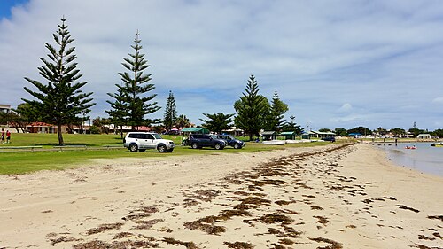
Photos of denison surf beach

More surf near here
1 place
- Dongara Point 3.6 km away
About
the place in full, sources, credits
About denison surf beach
Facing, offshore wind, exposure, level and swell range are estimated.
The spot faces W (286°), so it takes swell from the W. The wind blows offshore from the E (106°). It is sheltered to the open swell. It suits intermediate surfers and up. It works in 3–14 ft of swell. The sea floor shelves moderately: 10 m deep about 350 m out (1 in 37). On a typical 5 ft, 11 s swell the waves here would crumble. The sea is about 19°C in August, its coldest month (2 mm shorty), and 24°C in March, its warmest (no wetsuit). For intermediate surfers the best months are usually May and June, with about 3 good days in 7. From the weather of past years. The town to stay in is Port Denison, 0.5 km away (about 5 min by car). Within 5 km we also list 1 surf spot.
Water about 21°C: 2 mm shorty. Typical sea temperature for the time of year, not a forecast.
The score is the conditions only: the journey, the price and the partners never change it (how we score, how we earn).
Where to stay: 2 towns
Ad Links marked Ad may pay us if you book. You pay the same, and they never change a score. How we earn
about 5 min by car · 13 places to stay
about US$134/nightcountry average
About Port Denison its beds, food and every spot near it
- Beds in Dongara on Booking.com
about 5 min by car · 11 places to stay
About US$134 a night is our estimate of the country's average 2-star double room that month: not each town's price, and not a quote. Drives are estimates. Prices are about, in US Dollar (USD): our pound figures at the European Central Bank's rate of 30 October 2026.
Getting there
eSIM for your phone · Search on AiraloAd
An estimate, one way; the journey never changes the score.
In the water
Saved: this link opens the same trip
The link holds the trip itself: nothing about you is kept. Check the forecast again before you book.