

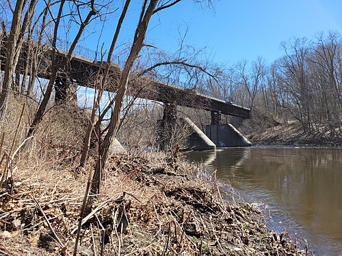

Farmington River
Kayak spot · United States
That date has passed, so this trip starts today.
Flat water: a lake, canal or slow river
Is it worth the trip?
95Good out of 100 for your dates
Best on Wed 4: Wind 6 kn gusting 15, Air 21 °C
Tue 3 · 97 out of 100
- Wind
- 6 kn
- Gusts
- 14kn
- Air
- 19°C
- Rain
- 0 mm
Wed 4 · 98 out of 100
- Wind
- 6 kn
- Gusts
- 15kn
- Air
- 21°C
- Rain
- 0 mm
Thu 5 · 92 out of 100
- Wind
- 8 kn
- Gusts
- 20kn
- Air
- 20°C
- Rain
- 0.5 mm
Fri 6 · 96 out of 100
- Wind
- 3 kn
- Gusts
- 7kn
- Air
- 18°C
- Rain
- 5.7 mm
Sat 7 · 97 out of 100
- Wind
- 5 kn
- Gusts
- 14kn
- Air
- 18°C
- Rain
- 0 mm
Sun 8 · 92 out of 100
- Wind
- 3 kn
- Gusts
- 10kn
- Air
- 15°C
- Rain
- 0 mm
Mon 9 · 78 out of 100
- Wind
- 7 kn
- Gusts
- 17kn
- Air
- 13°C
- Rain
- 1.5 mm
Tap a day for wind, gusts, air and rain. Full forecast
Forecast: next 10 days
Full forecast- Tue 397, good
- Wed 498, good
- Thu 592, good
- Fri 696, good
- Sat 797, good
- Sun 892, good
- Mon 978, good
- Tue 1081, good
- Wed 1168, good
- Thu 1282, good
The spot in one fact
- Flat waterthe water
Full forecast
every day, every number
The score doesn't know the river level, weirs or your skill.
| Day | Score | Wind | Gusts | Air | Rain |
|---|---|---|---|---|---|
| Tue 3Nov | 97, good | 6 kn | 14kn | 19°C | 0 mm |
| Wed 4Nov | 98, good | 6 kn | 15kn | 21°C | 0 mm |
| Thu 5Nov | 92, good | 8 kn | 20kn | 20°C | 0.5 mm |
| Fri 6Nov | 96, good | 3 kn | 7kn | 18°C | 5.7 mm |
| Sat 7Nov | 97, good | 5 kn | 14kn | 18°C | 0 mm |
| Sun 8Nov | 92, good | 3 kn | 10kn | 15°C | 0 mm |
| Mon 9Nov | 78, good | 7 kn | 17kn | 13°C | 1.5 mm |
| Tue 10Nov | 81, good | 6 kn | 24kn | 12°C | 0.6 mm |
| Wed 11Nov | 68, good | 8 kn | 17kntoo gusty | 10°C | 0 mm |
| Thu 12Nov | 82, good | 7 kn | 22kn | 10°C | 0 mm |
Wind and gusts are in knots, rain in mm. The river's level is under In the water. More
Forecast updated . It refreshes every three hours. Forecast data: ECMWF, DWD, Météo-France and NOAA, served by Open-Meteo.com (CC BY 4.0). Changed by us. Generated using E.U. Copernicus Marine Service Information.
Best time to go
No month stands out
Good kayaking days in a typical week, each month, for grade III paddlers, from 2016 on (ERA5 history scored the same way).
- Jan6of 7: a trip from Sat 2 Jan
- Feb6of 7: a trip from Sat 6 Feb
- Mar6of 7: a trip from Sat 6 Mar
- Apr7of 7: a trip from Sat 3 Apr
- May7of 7: a trip from Sat 1 May
- Jun7of 7: a trip from Sat 5 Jun
- Jul7of 7: a trip from Sat 3 Jul
- Aug7of 7: a trip from Sat 7 Aug
- Sep7of 7: a trip from Sat 4 Sept
- Oct7of 7: a trip from Sat 2 Oct
- Nov7of 7: a trip from Wed 4 Nov
- Dec6of 7: a trip from Sat 5 Dec
Tap a month to see this spot for a trip then.
Typical weather, not a forecast, and not the river's level: a month that is often good to be outside may still be low water.
Map
the spot and its town
Farmington River on Google Maps · Directions
Each place wears its best day on these dates: green good, amber fair, pale red poor, as the key says.
The map needs JavaScript. Every place on it is listed on this page, and each place's page links to Google Maps.
One finger scrolls the page; two fingers move the map. Pins are our own positions. Map OpenFreeMap, © OpenMapTiles, data © OpenStreetMap contributors.
Photos of Farmington River

About
the place in full, sources, credits
About Farmington River
A launch on the Farmington River. No grade stated: ask locally before you paddle. OpenStreetMap marks the water open to canoes and kayaks. None within 10 km, the nearest 25 km away. The town to stay in is Plainville. Within 5 km we also list 1 kayak spot.
- River Farmington River
- Grade No grade is stated.
- Who it suits No grade stated: ask locally before you paddle.
- Access OpenStreetMap marks the water open to canoes and kayaks.
- Schools, hire None within 10 km, the nearest 25 km away.
Spots and rivers: © OpenStreetMap contributors (ODbL). Whitewater sections © Rivermap (rivermap.org), Riverzone and Jonathan Riddell, ODbL.
The score is the conditions only: the journey, the price and the partners never change it (how we score, how we earn).
Rough cost (estimate): about US$1,110–US$2,030 each
about US$1,110–US$2,030 each · 6 nights, 2 sharing: flights, taxi, stay, food, kayak hire.
Our estimate from typical public prices, not a quote: check the real prices before you book (where they come from). Prices are about, in US Dollar (USD): our pound figures at the European Central Bank's rate of 2 November 2026.
How we worked it out
| What | How we worked it out | Each |
|---|---|---|
| Flights | return MDW to BDL, estimated from distance and season, 1 airline on the route, with a hold bag | about US$161–US$335 |
| Taxi | airport and back, shared | about US$60–US$101 |
| Stay | 6 nights, a mid-range double, shared | about US$349–US$584 |
| Food | 7 days eating out | about US$342–US$637 |
| Kayak hire | 5 days, or about US$114 to fly your own | about US$201–US$376 |
| Total | about US$1,110–US$2,030 |
Prices from public sources, checked in 2026.
Where to stay: Plainville
Ad Links marked Ad may pay us if you book. You pay the same, and they never change a score. How we earn
about 15 min by car · 4 places to stay
about US$134/nightcountry average
About Plainville its beds, food and every spot near it
About US$134 a night is our estimate of the country's average 2-star double room that month: not each town's price, and not a quote. Drives are estimates. Prices are about, in US Dollar (USD): our pound figures at the European Central Bank's rate of 2 November 2026.
Getting there: about 4h 50m
About 4h 50m door to door from Chicago
Fly MDW → BDL, direct, then 45 min by road
Flights MDW → BDL on your dates · AviasalesAd
An estimate, one way; the journey never changes the score.
On the water
Kayak trips and courses in Plainville · GetYourGuideKayak hire in Plainville · GetYourGuide
River level
Gauge at FARMINGTON RIVER AT UNIONVILLE, CT, 3 km upstream: 7.08 m³/s, low for November (updated 1 h ago). Running.
Bands are this gauge's own record: under its usual low, running, high, and in flood on its few highest days a year. Not a runnable range for the section: check before you go. River levels in the United States: U.S. Geological Survey (public domain). Credits
Paddling schools, clubs and hire nearby
No paddling school, club or hire with a name mapped within 25 km: the map has one 25 km away with no name.
Schools, clubs and hire: © OpenStreetMap contributors (ODbL). Credits
Saved: this link opens the same trip
The link holds the trip itself: nothing about you is kept. Check the forecast again before you book.